ST_LUCAS#
The use of in situ references in Earth observation monitoring is a fundamental need. LUCAS (Land Use and Coverage Area frame Survey) is an activity that has performed repeated in situ surveys over Europe every three years since 2006. The dataset is unique in many aspects; however it is currently not available through a standardized interface, machine-to-machine. Moreover, the evolution of the surveys limits the performance of change analysis using the dataset. Our objective was to develop an open-source system to fill these gaps.
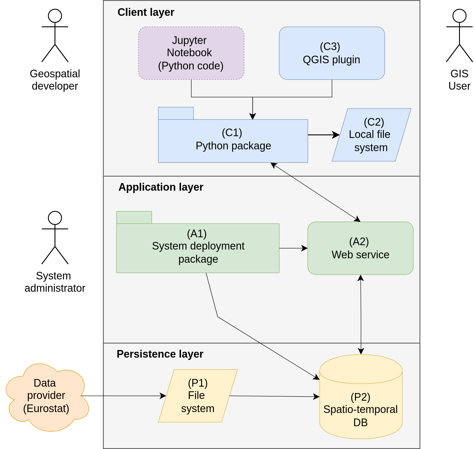
The ST_LUCAS is designed as a multi-layer client-server system that may be integrated into end-to-end workflows. It provides data through an OGC (Open Geospatial Consortium) compliant interface. A user may integrate the data through a Python API (Application Programming Interface) to ease the use in workflows with spatial, temporal, attribute, and thematic filters using the Jupyter Notebook or access the data interactively by the QGIS plugin.
Harmonized LUCAS attributes#
Coding tables#
Region-growing representative areas#
Spatially representative areas have been computed around LUCAS points in 2018 using an original shape-constrained region-growing algorithm. This algorithm was specifically designed to enhance the accuracy and consistency of machine learning approaches for land cover and land use mapping by ensuring that the delineated areas accurately represent the surrounding landscape. The algorithm takes as input the OSM/CLCplus land cover product (Zenodo), which provides a harmonized and detailed land cover dataset suitable for large-scale analysis.
To facilitate transparency and reproducibility, the tool developed for this purpose has been made openly available through a GitHub repository under MIT license, enabling researchers and practitioners to implement and refine the approach for various applications in land cover and environmental monitoring.
Coding tables#
Data extracts#
Dataset version: 2.0
Harmonized space-time aggregated LUCAS points (OGC GeoPackage)
LUCAS observation circles and Copernicus areas (OGC GeoPackage)
Versioned data extracts are also available from Zenodo.
Harmonization mapping tables#
System metadata#
License#
ST_LUCAS dataset#
ST_LUCAS dataset is provided under the same conditions (“free of charge”) as original LUCAS data (https://ec.europa.eu/eurostat/web/lucas/database/).
ST_LUCAS software components#
System Deployment Package (Gitlab repository) - MIT
Python Package (Gitlab repository) - MIT
QGIS Plugin (Gitlab repository) - GNU GPL
Funding#
This work is co-financed under Grant Agreement Connecting Europe Facility (CEF) Telecom project 2018-EU-IA-0095 by the European Union.